Australian Tax Treaties
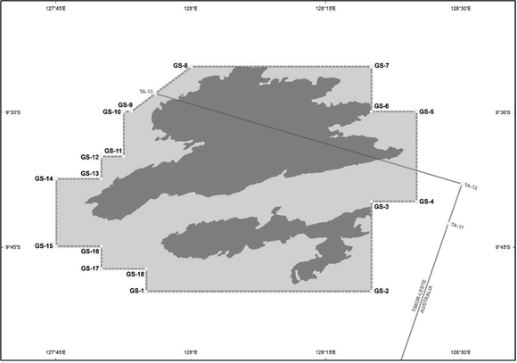
| Point | Latitude | Longitude |
| GS-1 | 09 ° 49 ' 54.88 " S | 127 ° 55 ' 04.35 " E |
| GS-2 | 09 ° 49 ' 54.88 " S | 128 ° 20 ' 04.34 " E |
| GS-3 | 09 ° 39 ' 54.88 " S | 128 ° 20 ' 04.34 " E |
| GS-4 | 09 ° 39 ' 54.88 " S | 128 ° 25 ' 04.34 " E |
| GS-5 | 09 ° 29 ' 54.88 " S | 128 ° 25 ' 04.34 " E |
| GS-6 | 09 ° 29 ' 54.88 " S | 128 ° 20 ' 04.34 " E |
| GS-7 | 09 ° 24 ' 54.88 " S | 128 ° 20 ' 04.34 " E |
| GS-8 | 09 ° 24 ' 54.88 " S | 128 ° 00 ' 04.34 " E |
| GS-9 | 09 ° 29 ' 54.88 " S | 127 ° 53 ' 24.35 " E |
| GS-10 | 09 ° 29 ' 54.88 " S | 127 ° 52 ' 34.35 " E |
| GS-11 | 09 ° 34 ' 54.88 " S | 127 ° 52 ' 34.35 " E |
| GS-12 | 09 ° 34 ' 54.88 " S | 127 ° 50 ' 04.35 " E |
| GS-13 | 09 ° 37 ' 24.88 " S | 127 ° 50 ' 04.35 " E |
| GS-14 | 09 ° 37 ' 24.89 " S | 127 ° 45 ' 04.35 " E |
| GS-15 | 09 ° 44 ' 54.88 " S | 127 ° 45 ' 04.35 " E |
| GS-16 | 09 ° 44 ' 54.88 " S | 127 ° 50 ' 04.35 " E |
| GS-17 | 09 ° 47 ' 24.88 " S | 127 ° 50 ' 04.35 " E |
| GS-18 | 09 ° 47 ' 24.88 " S | 127 ° 55 ' 04.35 " E |

This information is provided by CCH Australia Limited Link opens in new window. View the disclaimer and notice of copyright.
